![]()
![]()
![]()
![]()
![]()
DOWNLOAD GRIERSON FAMILY TREE (pdf)
Grierson ~ First
Generation
| FAMILY
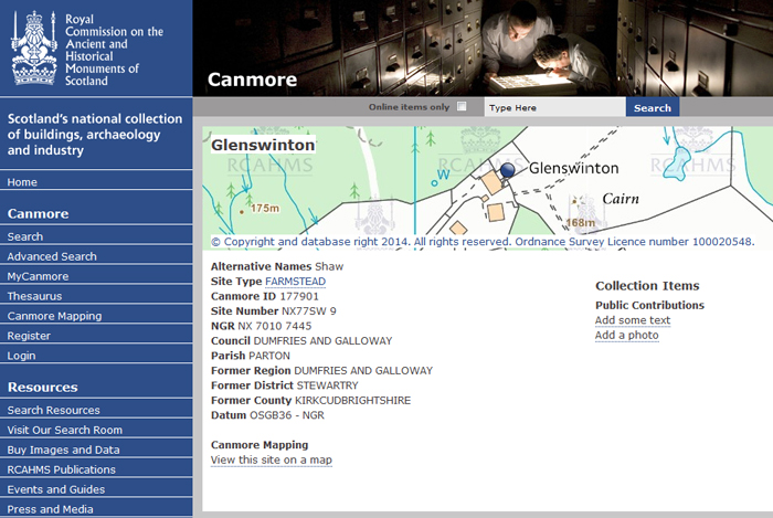
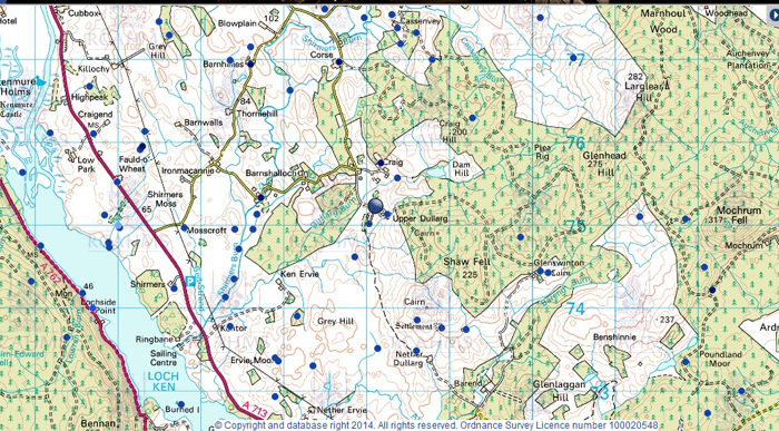
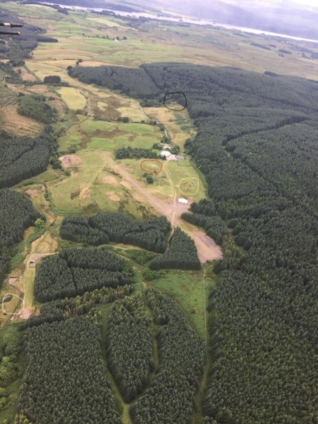
TRADITION Knowledge of our family indicates that their geographical position in the eighteenth century was centred on Kircudbrightshire and Dumfriesshire, otherwise known as Galloway, in Scotland, and specifically around the area of Parton, a small village several miles north of Castle Douglas. There is a tradition in the family that John Grierson (born 1778) was descended from William, a relative of Rob Roy MacGregor. In 1900, John (2) Grierson dictated a letter to his grand-daughter Florence as follows: "Rob Roy MacGregor was outlawed, but William, either a son or a brother, settled on the land and lived peaceably on the banks of the river Dee. Among his descendants were Robert and John 1st; their father was supposedly wealthy having inherited property from William MacGregor his ancestor." Present-day Y-DNA studies have entirely excluded the theory of a direct male MacGregor descendancy. The best Y-DNA evidence that we have in respect of a connection to 'Bloody' Sir Robert Grierson, the Laird of Lag, is that we are distantly related to his near relatives. A vast number of Grier(son)s in the same general area of Scotland probably descended from the same line as the family of Lag, and J. David Grierson has calculated that fully half of the farms within a few miles radius of Parton had a Grierson farmer or wife at some time during the 18th century. THE FARMS KNOWN AS SHAW, CAIRN AND/OR GLENSWINTON John and Janet and family (see below) probably resided at farms called variously Shaw, Cairn and now Glenswinton, three miles north of Parton village, about one mile due east of Upper Dullarg, and not far north of Castle Douglas, certainly during the period between 1758 and 1778 and possibly longer. The farms Shaw and Cairn were adjacent to one another. The tenancy reference in the Parton records changed from Shaw to Cairn between 1764 and 1766. There is a map drawn by the Dutchman Timothy Pont about 1591 which shows the name Glensuyntouns in approximately the right place by reference to local landmarks. The following maps show more information: Link to the Shaw farm, 1849 https://maps.nls.uk/view/74427637#zoom=6&lat=3244&lon=12607&layers=BT Link to the Parton Church, 1849 https://maps.nls.uk/view/74427644#zoom=7&lat=6229&lon=12226&layers=BT Link to Dunjop farm, 1849 https://maps.nls.uk/view/74427651#zoom=6&lat=2070&lon=14753&layers=BT Recent photo of the Cairn and Glenswinton https://www.geograph.org.uk/photo/723188 Further information about the farm was supplied by Sam Callender of the Parton Kirk: "At a recent exhibition in the parish of bygone times there was a photocopy of an entry from the Rev. Mr. William Donaldson (approx 1791) for the statistical account of the Parish of Parton and the part on antiquities reads 'near the church there is an artificial mound, 120 yards in circumference at the base, which is circular. It is surrounded by a ditch from 6 to 9 feet deep, whence the earth which composes the mount appears to have been taken. About half a mile north there is another mount, nearly double the dimensions of the former, enclosed with two ditches. On a gentle eminence at 200 yards distance is seen the remains of a small druidical circle. About 3 miles north from the church there is a remarkable heap of stones from which the farm where it lies seems to have been named The Cairn.' " In another document, Sam Callender gave his opinion that a chieftain's grave lay on the farm, i.e. the grave of a very powerful man of about 3500 years ago. In 1986, J.D.Grierson visited Shaw / Cairn / Glenswinton, met the owner, stood on the Cairn and took many photos. With thanks to him for many research notes on this page. The owner told him that according to the deeds, the house in 1720 was generally rectangular, about 18 feet by 30 feet; it had two rooms downstairs, and the whole upstairs was a single room loft in which all slept. This was only six feet high at the ridge, sloping to zero at the walls. Since then, at times unknown, the house had been lengthened, the windows enlarged, a westward projection added, and the first floor rebuilt so that the original roof line no longer exists. There is now some doubt as to which house Mr Widdup was referring. In "History of the Lands and their Owners in Galloway Vol 5" by P.H.McKerlie, which is regarded as an authority in the area, the following information about the lands in which we are interested in the parish of Parton is found: "... after 1695 there is no specific information until in 1799 Shaw, Upper Dullarg and Arvie (Upper and Nether) belonged to Walter Sloan-Laurie of Redcastle. These were next owned by Walter Kennedy-Laurie of Woodhall, who sold Shaw to John Birney of Glenswinton, Ireland. This owner renamed the land.." Recent research has demonstrated that there are factual errors here, see the attached research paper. We now know the ownership of these farms in great detail. Given the earliest known record relating to Cairn involving a Grierson family (1671) and the supposition that our family moved from Cairn at about the beginning of the 19th Century, it is very likely that a long-term multi-generational tenancy existed. Also attached is a photo of modern Glenswinton from the east, with Loch Ken in the background. There are four circles on it: black is the site of the original SHAW; red is the physical cairn; yellow appears to be the foundation of the original CAIRN farmstead; white (bottom left) is the site of GLENHEAD. So whilst the farms were three separate entities, their farmsteads were neighbourly. EARLY RECORDS The earliest mention of the property Cairn that has been found is in 1674, from the Calendar of Deeds - Kircudbrightshire Sheriff Court - 1625-1675, transcribed at the instance of the Marquis of Bute. "Obligation (1[st] December 1674) made at Clauchan of Dalry 9[th] January 1671 - John Greir in Cairne & Roger Greirsone, his son owe L37 Scots to David Chartors, burgess in New Galloway." [Note: Clauchan/Clachan = village or village inn; Dalry is 10km NW of Cairn] [supplied by J.D.Grierson from the late Crawford Grier from many early legal records from Kirkcudbright and Dumfries] EARLY PARISH RECORDS An early record from the parish of Parton in Kircudbrightshire, Scotland (where all the children in generation 2 were baptised, and which is close to the river Dee) is the following: "September 12th 1714. Baptisms. Imprimis September 12 1714 William Grier Margaret Gorran had a lawful child baptised called John". ("imprimis" means "in this place", and "lawful" means that they were married.) It is possible that this is the baptism record of John GRIER below, who later married Janet McMonnies, but there would be a very large age gap between them if so. ScotlandsPeople has been searched for a marriage anywhere of a Margaret Gorran in the correct time period, but none are listed. It is not possible at this time to say where this William Grier came from. This William may be the source for the William referred to in the family MacGregor legend; however, DNA studies have shown that an immediate connection between the MacGregor clan and the male line of the our Griersons is not supported. A further event to be investigated is the record of "Robert of Shaw died 1754 as a young man" who died before John Grierson married Janet McMonnies, and who very well may have been John's brother. Deaths 10th March 1754 Robert Grierson a young man at Shaw." Margaret Gorran died at the family farm, as described in the Parton register entry below, which confirms that she was a close relative (she would have been John's mother based on the supposition above). "Deaths 3rd May 1770 Margaret Gorran in Cairn, aged." J.David Grierson has supplied the following notes on the Gorran family. 'There are a number of Gorran and Gerran events recorded at Parton, and several mentions of variations on the name in nearby parishes. At Parton, three Gorran women were married or had children in the early part of the 18th Century. Gorran has the double "r" in all entries I have seen anywhere. This is a very interesting name in that it is extremely rare in Scotland (I can't find any in England) and probably died out in the middle 18th Century. Isobell Gorran and Jean Gorran, presumably Margaret's sisters, were both married at Parton in 1715, and a Rachel Gorran had several children in the period. Thereafter, only deaths are recorded, including, I think, their father. I suspect from what I've found that the family was well established on the land and in the Church during the 17th Century. For example, in Edinburgh there is a Testament for Ninian Garrane in Laggane 1584. "Laggan" is a group of farms, now known as "Over Laggan", "Diamond Laggan", "Mid Laggan" and "Nether Laggan" which are, as it happens, situated between "Cairn" and the village of Parton.' There are no extant birth records for the old parochial registers of Parton for the period 1717 to 1745 unfortunately. FIRST DEFINITE FORBEARS John GRIER of Parton, Kircudbrightshire, Scotland. John married Janet McMONIES or McMONNIES. Janet was baptised on 21 Jun 1733 at Tongland, Scotland, daughter of GEORGE McMONIES (a Menzies Sept) and (unknown) DAULING or PAULING (ref Tongland register though it is indexed in Scotlands People as Dauling so that is probable more accurate). Jane had a sister Margaret McMonies who was bap on 3 July 1735 at Tongland, also daughter of George McMonies and (unknown) Dauling (ref Scotlands People). The marriage of George McMonies has not been found. The IGI record states they married 25 Aug 1757, at Parton, Kircudbright, Scotland (ref IGI record). However, the actual words recorded in the old parochial registers of Parton are as follows: "13th August 1757 John Grier (sic) in this parish and Janet McMonnies in Tongland gave in their names in order to proclamation and were wedded at Dunjap (sic) on Thursday 25th August by Mr. Alexander Brown." The spelling of Dunjap is believed to represent the farmhouse of Dunjop in the northern part of the parish of Tongland in Kircudbrightshire. Dunjop is situated close to Bridge of Dee, a short distance west of Castle Douglas, and can be found on the website of the Royal Commission on the Ancient and Historical Monuments of Scotland ("Canmore"). According to this website which has a plan of the site, it is in the parish of Tongland in the former county of Kirkcudbrightshire. In the 1753 land Tax rolls, the notation clearly is: Dunjap in Tongueland. By 1853, it is Dunjop in Tongland. So the marriage registration reflected the spelling of the day, and it is the same place. It is possible that John died by 1805 and that his son Robert inherited the money to get the properties in Castle Douglas, but no evidence for this. No death around this time for a John Grier or Grierson has been found, nor any Wills & Testaments on ScotlandsPeople. |
IGI record
Tongland
Register |
|
| Children: | ||
| 1. | Margaret GRIER bap 1758 at Parton, Kircudbrightshire | |
| 2. | John GRIER (1) bap 1762 at Parton, Kircudbrightshire | |
| 3. | William GRIER bap 1764 at Parton, Kircudbrightshire | |
| 4. | George GRIER bap 1766 at Parton, Kircudbrightshire | |
| 5. | Robert GRIERSON bap 1768 at Parton, Kircudbrightshire | |
| 6. | Jannet GRIERSON bap 1770 at Parton, Kircudbrightshire | |
| 7. | Mary GRIER bap 1775 at Parton, Kircudbrightshire | |
| 8. | John GRIERSON (2) bap 1778 at Parton, Kircudbrightshire |
![]()
![]()
![]()
![]()
Last modified 26
Jul 2021