| 1. |
|
William GRAVE
Possibly born c1756 (see below). No suitable
baptism has been found in Torpenhow or Allhallows parish
records or in FamilySearch. There are other possibilities
in Cumberland such as William Grave and Margaret Young of
Cockermouth, which is documented in FamilySearch, which
is likely but not proved.
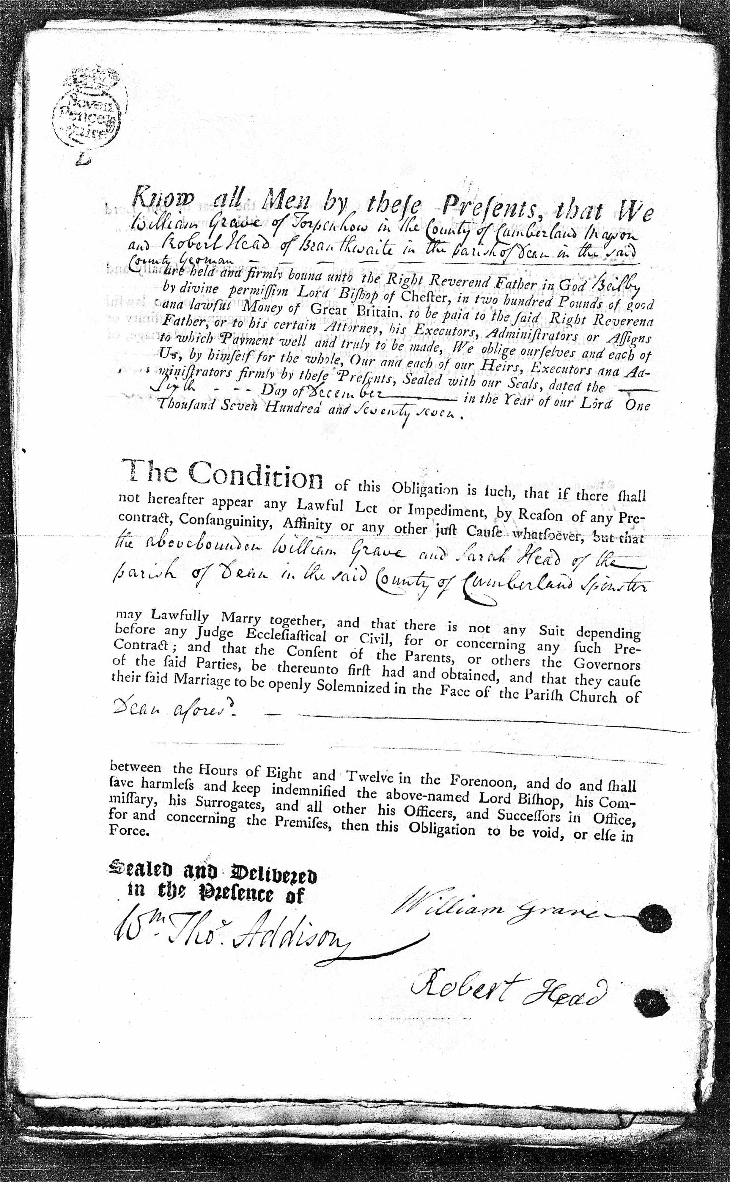
William Grave and his future father-in-law Robert Head
signed a marriage application on 6 Dec 1777 which is
attached. It states that William was of Torpenhow in the
County of Cumberland, and that Robert Head was of
Branthwaite in the parish of Dean in the same county,
Yeoman; it gives William's age as 21 years and upwards,
and Sarah's as 27 years. This is slightly older than
expected by her baptism below but matches sufficiently.
Calculating by William's death, he would have been only
about 21.
Marr 7 Dec 1777 at Dean, Cumberland, England of
William Grave to Sarah HEAD (ref IGI).
Sarah was baptised 24 Feb 1753, dau of Robert Head &
Sarah Wood, at Dean, Cumberland. Calculating by Sarah's
death, she would have been born about 1753.
It may have been that William owned the quarry at Baggrow
referred to in a later generation.
In 1790/91 and 1794/95, William Grave is listed in the
Allhallows Parish records as a Churchwarden.
In 1787, 1789, 1791 and 1793, William is described as a
mason of Bagraw (from baptisms in fmp). In 1795 he is a
farmer of Bagraw.
In 1798 William Graves is listed as the occupier of a
property in the parish of Allhallows owned by Sir Wilfred
Lawson, Bart. for Land Tax of 10s. 5d. (ref Ancestry, UK
Land Tax Redemption).
On 13 Jan 1815 there is a burial registered of William
Grave of Bagraw aged 59 years in the Allhallows Bishops'
Transcript. This would make his birth c1756. There are
several possible baptisms for a William Grave in
Cumberland at this time. William Grave is listed in the Index to
Death Duty Registers in fmp, naming his son Samuel of
Bagrow as administrator.
On 31 Jan 1828 There is a burial registered of Sarah
Grave of Blenerhasset aged 75 years in the Allhallows
Bishops' Transcript. This would make her birth c1753.
See Slater's Directory of 1855 for the geography of
Aspatria and Allhallows.
.
***********************************************************************************************************************************
ALLHALLOWS CHURCH
Excerpts from an undated booklet obtained in
2009 from All Saints Church, the Parish of Allhallows,
Mealsgate (the new church).
Links with Aspatria
The Parish of Allhallows was originally no more
than a chapelry within the Parish of Aspatria, and known
as the Chapelry of All Saints of Ukmanby. The old church,
as it is now called, was then the only church and was
served by the vicar of Aspatria or by a chaplain, and the
parishioners of All Saints were expected to attend church
at Aspatria one day in the year, namely the day of the
dedication of the parish church of Aspatria. This was in
the days of Henry VI in the 15th century.
The Parish Boundary
"The Parish or chapelry is bounded by
Dowbeck from Mealsgate to the park wall at Whitehall
below the church of Allhallows, so along that wall
Southward to the highway leading to Cockermouth, then
along that road to Cockbridge, then down Elne to Aspatria
Mill, then by the North side of Elnebridge close to the
foot of Brayton Demense from Baggray to the common, and
along the skirts of the common by King Yeat, Ucmanby, and
Leesrigg to Priest Croft, and from thence to Meal's Gate
where the boundary began." Nicholson and Burn
1777.
The Old Church
All that is left of the old church after the
demolition in 1935 of the nave, south aisle and porch, is
the chancel and its attached mortuary chapel. There is a
public footpath to the remains of the old church,
opposite the present church, which comes out into a layby
on the A595.
The old church was built in the 12th century, between
1154-1189 and only in the 19th century did it become a
fully independent parish church.
***********************************************************************************************************************************
MAP OF THE PART OF CUMBERLAND MOSTLY REFERRED TO
IN THIS FAMILY TREE
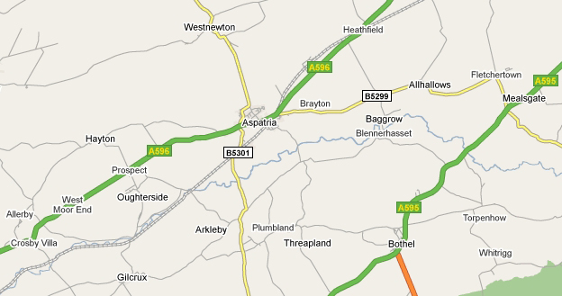
FROM WHOM FREDERICK
SHADE IS DESCENDED.
|
Marriage application
IGI
records
1855
Slater's Directory
(pdf)
|